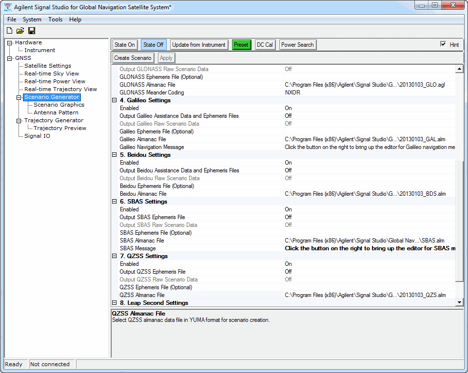
Scenario Generator Settings Figure:
This procedure guides you through the settings to create a scenario using the node on the software's user interface (UI). To learn more about individual cell settings, refer to the UI descriptions.
Scenario Generator Settings Figure:
Click in the tree view.
Notice that the is set to, which is the default setting.
Click Comment and add text if there is a need to add a comment to the scenario.
The comment entered here also appears if the scenario is modified with the Edit selection of the Generation Mode property.
Set the
The software sets the mask from the horizon to the angle entered. This means that the software only recognizes satellites that appear above the mask value.
If desired, set the to or leave as .
Some tests, such as in the 3GPP standards, require the model selection.
Select the : or .
If is the Ionosphere Model, set the parameters for the cell that appears after making the selection:
Click on the + sign displayed to the left of the cell to display the and cells.
Set the Alpha and Beta parameters.
If a particular test from the 3GPP standards includes these values, set the and cell values to match the 3GPP test values.
Configure the settings for either Static
or Dynamic
(moving GNSS receiver).
If you select , the software removes some settings (cells) that are requirements only for the selection.
Set the of the scenario simulation. While the software automatically sets the start date, if there is a need, user input is allowed to overwrite these values:
For static scenarios, the start date is automatically updated by TOA (Time of Applicability) information in the selected almanac files.
For dynamic scenarios, the software always uses the start date from the NMEA message, which is determined by the first RMC message in the NMEA message file. However, user input is allowed if there is a need to overwrite these values. If the RMC messages are not included in the NMEA message file, the scenario uses the TOA from the selected almanac. The user may want to manually change the date to the one that they want to simulate.
Set the date by either manually entering the date, or by clicking the cell and using the dialog box button  to launch the Date Time Editor. By using the editor, you can set both the Start Date and Start Time (GPS Time) values. The start date and time must be later than 1980-01-06 00:00:00. It is recommended to use a start time on a 6 second boundary, because GPS time-of-week is counted in units of 6 seconds.
Set the of the scenario simulation. While the software automatically sets the start time, if there is a need, user input is allowed to overwrite these values:
For static scenarios, Start time is automatically updated by TOA information in the selected almanac files.
For dynamic scenarios, the start time is determined by the first GGA message in the NMEA message file. However, user input is allowed if there is a need to overwrite these values.
Set the time by either manually entering the time, or by clicking the cell and using the dialog box button to launch the Date Time Editor. By using the editor, you can set both the Start Date and Start Time (GPS Time) values. The start date and time must be later than 1980-01-06 00:00:00. It is recommended to use a start time on a 6 second boundary, because GPS time-of-week is counted in units of 6 seconds.
Set the constellation type settings (GPS Settings, GLONASS Settings, etc.):
For each constellation required to be in the scenario, set their property to otherwise set it to .
For all constellations with set to , set their remaining properties.
Refer either to hints embedded in the software UI, or use the Scenario Generator UI descriptions, which may have more information than the hints such as URLs to almanac files and special considerations.
Set the .
You can choose either (defined by IERS) or .
Selecting provides the additional cell that gives you access to the Leap Seconds Editor where you can create your own leap seconds configuration.
Set the Antenna Pattern Settings:
Set the cell to either or .
If set to , the software configures a gain mask and adds three additional cells covered in the remaining substeps:
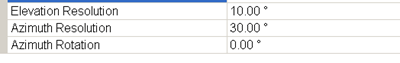
If desired, change the values for the Elevation Resolution, Azimuth Resolution, and Azimuth Rotation cells by clicking the cell and entering a value.
The values in these cells affect the Antenna Pattern display shown in the node.
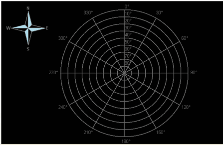
Select the node.
Configure the Antenna Pattern gain mask.
Select the node.
Click the button to launch the dialog box for selecting a location and saving the file.
After creating the scenario, click on the Scenario Graphics node to view the satellites used during the time of the scenario for each channel.